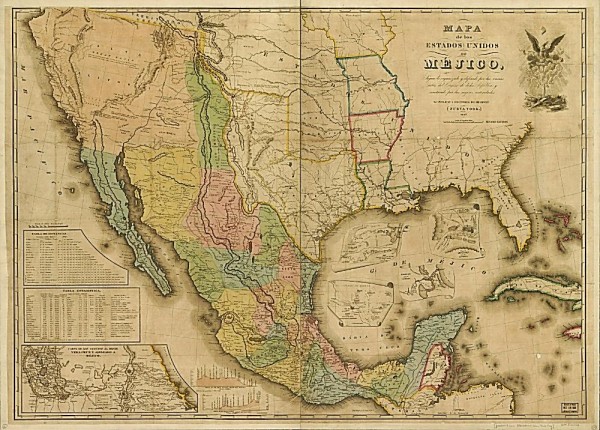
(Map 1: US Borders Prior to the Treaty of Guadalupe Hidalgo*)
With all the discussion, both in the current election cycle and year in and year out, about immigration to the US, as well as how to secure the US’s southern border, what often gets ignored is how the US got its southern border. Specifically the human geography of the southwestern US and their relationship to its border. After the conclusion of the Mexican War, in February 1848, the US and Mexico completed the negotiation of the Treaty of Guadalupe Hidalgo. The Treaty of Guadalupe Hidalgo did several things, but among them it moved the US’s southern and western borders to roughly where they are now. Basically we moved the line on the map. As was, and still is, the case when borders are drawn the people living on either side of the old and/or new borders do not always pay a lot of attention to that border in their daily lives. This can be seen in kinship maps of various parts of the world where borders were drawn, often by people far from where the borders were or would be, that subdivided or bisected members of kinship groups into separate states regardless of the reality on the ground. You can see this on ethnic maps throughout Africa, the Middle East, Central Asia, and other parts of the world.
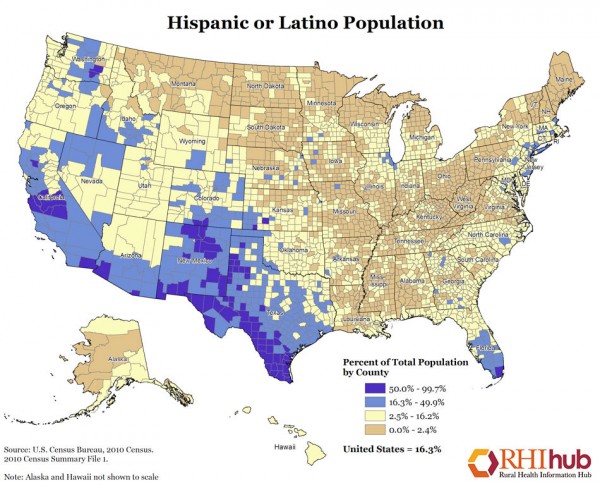
This is also the reality with the US’s southern border. The Treaty of Guadalupe Hidalgo officially moved the lines on the map, but the day to day experience – the pattern of human settlement and the human geography of the region did not really change. Sure, more of what we now call non-Hispanic whites moved into New Mexico and west Texas and Arizona and Southern California, but the overall human geography – the people, places, and things that make up that pattern of human settlement didn’t change all that much. If you look at the pattern of settlement, based on 2010 Census data, you’ll see that where Hispanics and Latinos were living in the southern US hasn’t changed a lot. The highest density areas are still in the southwest.

(Map 2: Hispanic or Latino Population of the US**)
You’ll notice that on both the map prepared for the negotiations of the Treaty of Guadalupe Hidalgo and the Rural Health Information’s map of Hispanic or Latino population of the US based on the 2010 Census that the area that the US would get from Mexico in 1848 is still where the largest percentage of the Hispanic or Latino population of the US live. This doesn’t count south Florida, which has a different historic pattern of Hispanic settlement. What the patterns of settlement shown on the maps show us is that the border was moved on the map, but the pattern of settlement remained largely unchanged.
And off and on for almost a hundred years that border was open. People went back and forth for familial reasons, for economic reasons, for social reasons, and for political reasons (don’t forget the Mormon exodus to Mexico in the late 19th Century and their return to the US in the early 20th Century). At different times throughout the 20th Century there have been attempts to seal the southern border for security reasons, which were sometimes/often conflated with xenophobia and anti-immigration sentiment. There were also attempts by the Mexican government to police their northern border to prevent (accused) criminals from crossing into the US illegally to escape justice. And all of these, over the course of a decade in the 1940s into the 1950s culminated with Operation Wetback – the last, named operation to deal with the issue at that point in time. These efforts to regulate the southern border also included guest worker programs, like the early 1940s Bracero Program. In the 1980s the Reagan Administration pushed the Immigration and Reform Act of 1986 that included a pathway to citizenship. Later, in the 1990s, there was Operation Gatekeeper, the Clinton Administration attempt to secure the southern border. And there was also the disastrous impact of NAFTA and the war on drugs on Mexico’s economy, driving millions north in search of work to support themselves and their relatives at home. And through it all the pattern of settlement in the southwestern US has not changed very much. Until this reality – that the border may have been moved in 1848, but not the demographics of the population – is acknowledged in the debate on what to do with the migration across the US’s southern border, then it will not be possible to formulate feasible, acceptable, and suitable policies for immigration into the US across the southern border and how to best regulate and regularize it.
* Map found here.
** Map found here.