On the Road is a weekday feature spotlighting reader photo submissions.
From the exotic to the familiar, whether you’re traveling or in your own backyard, we would love to see the world through your eyes.
Good Morning All,
On The Road and In Your Backyard is a weekday feature spotlighting reader submissions. From the exotic to the familiar, please share your part of the world, whether you’re traveling or just in your locality. Share some photos and a narrative, let us see through your pictures and words. We’re so lucky each and every day to see and appreciate the world around us!
Submissions from commenters are welcome at tools.balloon-juice.com
For each picture, it’s best to provide your commenter screenname, description, where it was taken, and date. It’s tough to keep everyone’s email address and screenname straight, so don’t assume that I remember it “from last time”. More and more, the first photo before the fold will be from a commenter, so making it easy to locate the screenname when I’ve found a compelling photo is crucial.
I had internet service issues that turned out to be both router and modem-based (though I received an “all-clear, problem resolved” text from support while I was deeply asleep at 4 AM, you bastards) and not so much service-based. I ended up buying new cable modem and WiFi router, and they all worked well.
And then I was away, knowing internet service was restored at home but when I needed to, I couldn’t connect to my home-office/work machine because I hadn’t configured port forwarding, etc. And since I was away, I was SOL. And so I apologize, yesterday was supposed to be Africa. Tomorrow will be, and Friday will be the overdue West and I’ll punt otmar (if he’s submitted!) until next Friday.
Sigh. Sometimes I think I should throw tech aside and work with non-digital things.
Have a Happy Halloween, folks!
Today, pictures from valued commenter ?BillinGlendaleCA.
I’ve documented a few hikes I’ve taken with my step-daughter(Echo Mountain and Mt. Lowe), most of these have been a lower elevations and the vegetation has been less than foresty. The kid has been yearning for a hike in the forest, I suggested Mt. Pinos, about a 90 minute drive from Glendale. The problem with Mt. Pinos is that due to it’s elevation it actually gets quite a bit of snow, sometimes sticking around until early July in places. While some might not find driving and hiking in 4-6 feet of snow to be a problem(fellow jackal jl questioned my dedication), both the kid and I are native Southern Californians and are neither used to driving or hiking in snow. We finally found a day that worked with her schedule at the hospital and that would be snowless and proceed to drive up to the mountain. Most of the climb to the summit is by car, ending at a parking lot at the 8400′ level. The trail to the summit is actually a road(there’s an Air Force radar installation at the summit) and it’s only about a 2 mile hike.
Mt. Pinos is a 8847 foot high mountain northwest of Los Angeles and is the highest point in both Ventura County and Kern County(the county line bisects the summit). It’s made previous appearances in On The Road as the foreground for star trails that were shot in Lockwood Valley at the foot of the mountain as well as a Milky Way picture that was shot on the mountain. Immediately north of the mountain is the San Andres Fault that runs though a valley separating Mt. Pinos from the mountains further north at the southern edge of the Central Valley. The native Chumash people considered the mountain to be the center of the World.
Taken on 2017-12-01 00:00:00
Mt. Pinos, California
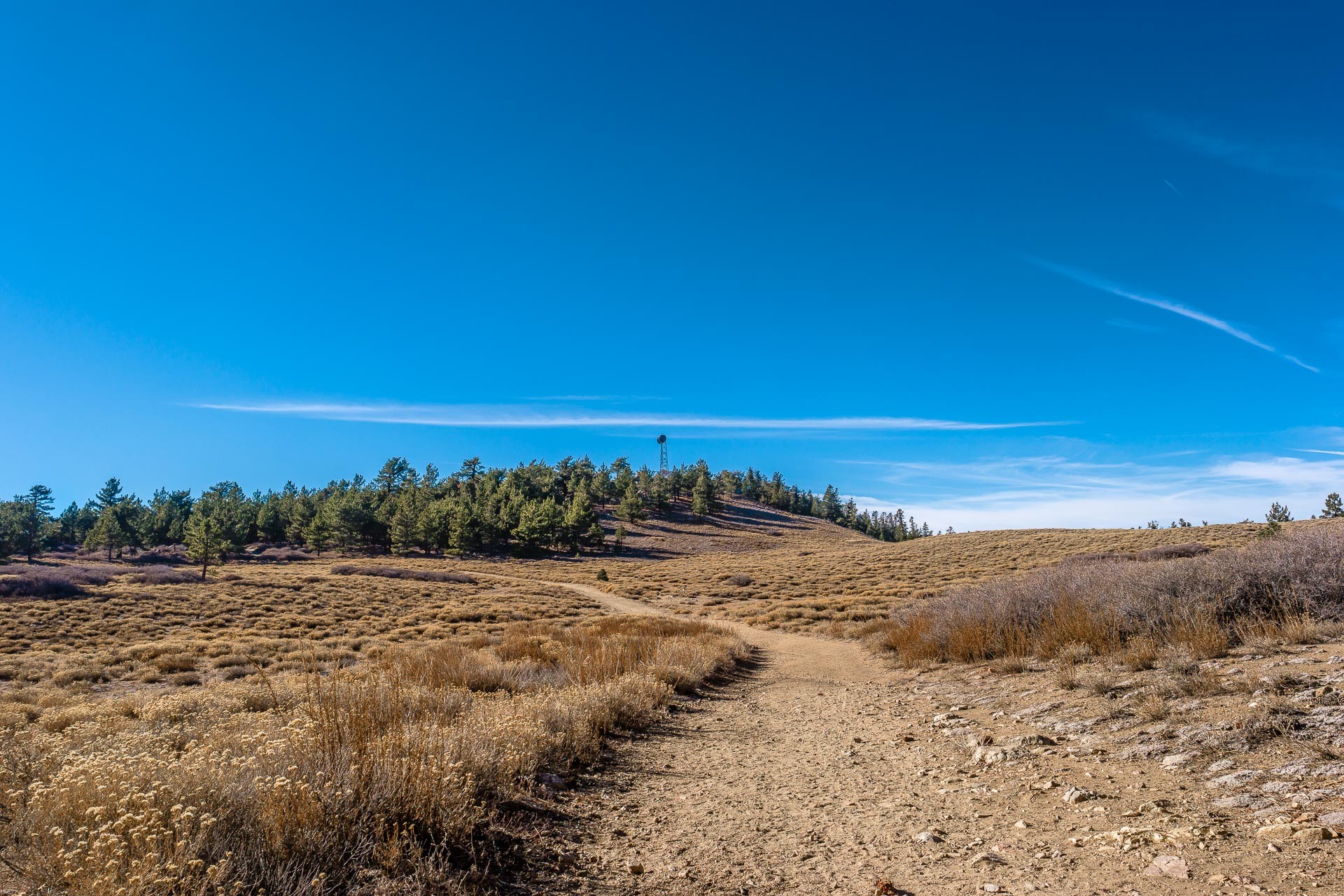
The kid asked for a hike in the forest, and I provided a hike in the forest. We rounded a bend in the road and there was this pine tree(Mt. Pinos in named after the pine tree), the perfect size and shape for a Christmas tree. At the left side of the photo you can see the trail curves over to the Christmas tree and the back didn’t look as well defined as the front.

Taken on 2017-12-01 00:00:00
Mt. Pinos, California
After the first half mile or so, we took a short break in front of this rock formation(we were both not used to hiking in higher elevations). These formations are all over the mountain.

Taken on 2017-12-01 00:00:00
Mt. Pinos, California
After waking though the forest, you come upon an alpine meadow with the wooded summit just past the meadow. You can see the Air Force installation right in the center of the picture.
Taken on 2017-12-01 00:00:00
Mt. Pinos, California
Once we reached the summit, we first went to the condor viewing area. They had some benches and some interpretive displays about the condors. Unfortunately there was a guy there that was talking rather loudly to himself(he could have been on the phone), so we went to the western flank of the summit. The summit is pretty large and flat. This picture looks north with the Central Valley in the haze to the right and the Coastal Range on the left. The mountains in the foreground to the right are on the other side of the San Andres Fault that runs though the valley.
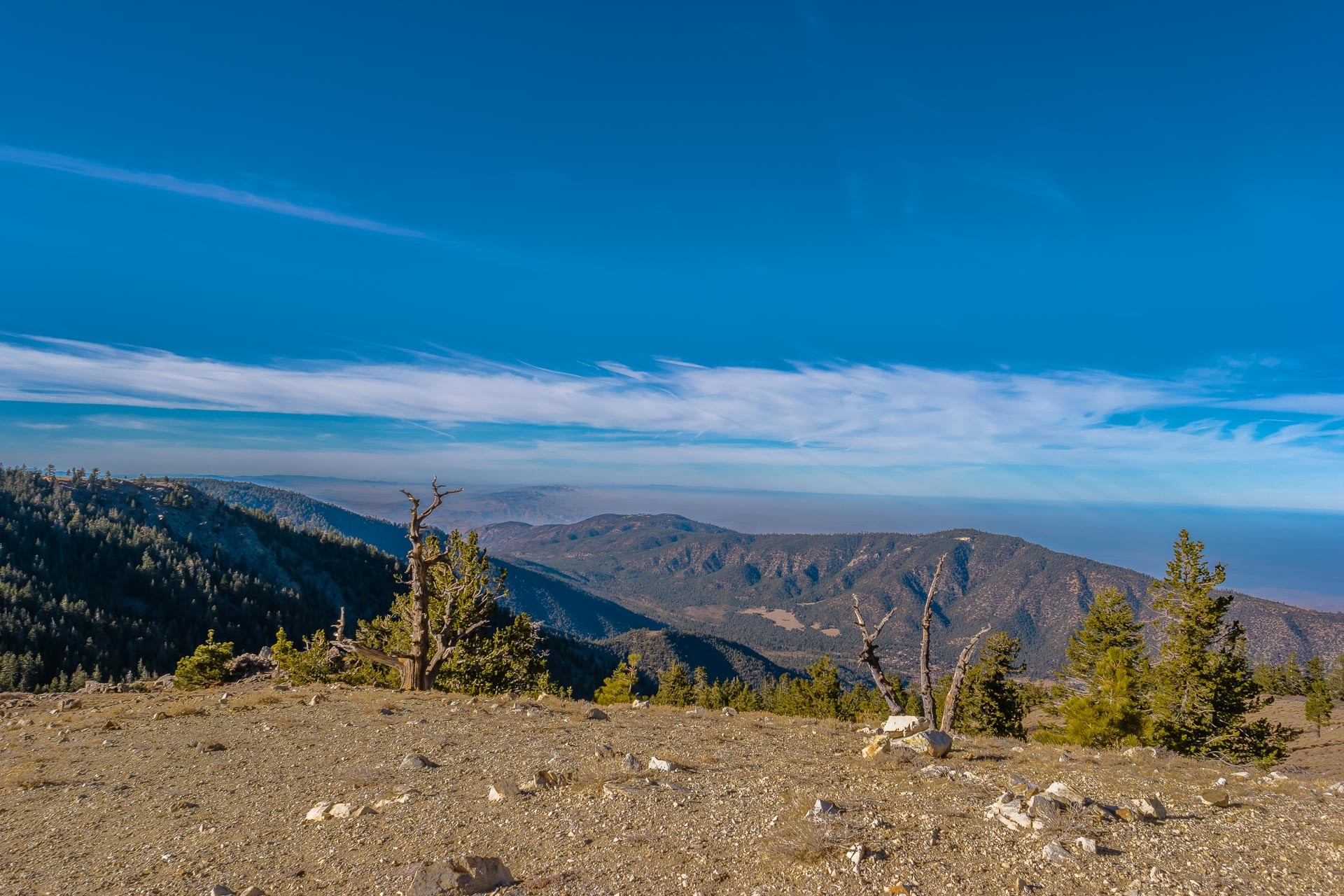
Taken on 2017-12-01 00:00:00
Mt. Pinos, California
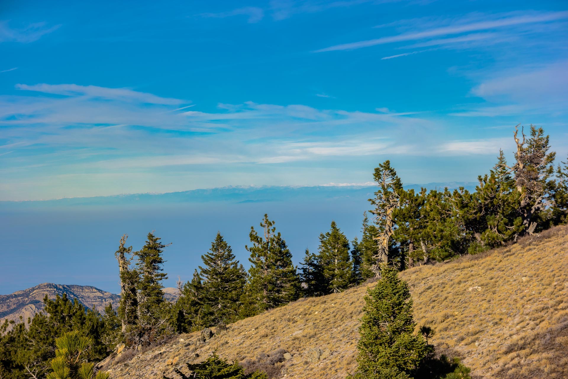
Until this hike, every time the kid and I have gone hiking, we’ve had crappy visibility(either smog, marine layer, or clouds). This hike was much different. This view looks east to the Sierra, and you can see the snow capped peaks of the eastern Sierra about 120 miles away. The mountain that you can see just left of the tree is the western face of Mt. Whitney(the tallest peak in the lower 48 states) and just left of it is Mt. Williamson, the second highest peak in California.
Thank you so much ?BillinGlendaleCA, do send us more when you can.
Travel safely everybody, and do share some stories in the comments, even if you’re joining the conversation late. Many folks confide that they go back and read old threads, one reason these are available on the Quick Links menu.
One again, to submit pictures: Use the Form or Send an Email
JPL
Beautiful!
?BillinGlendaleCA
@JPL: Thanks, the visibility jinx has returned. Madame, the kid and I were supposed to go to Mt. Lowe on Monday; but I had some uncomfortable dyspepsia and had only slept about a hour and the basin was completely hazy with less than a mile visibility. We ended up hiking with the dogs in Griffith Park.
debbie
I especially love the first shot of that forest!
?BillinGlendaleCA
@debbie: Wouldn’t that pine tree make the perfect Christmas Tree? We did take that hike at the beginning of December, so we were thinking of Christmas.
Steve in the ATL
I take photos like those when I go hiking, yet somehow yours are much, much better.
Photography must work like golf—there is nothing wrong with my skill, I just need a better camera!
Steve in the CLE
?BillinGlendaleCA
@Steve in the ATL: The camera helps, but you have to do post(use a program to get the exposure and color right). I use Lightroom and Photoshop for special fixes.
ETA: Are you in CLE for CLE?
Steve in the ATL
@?BillinGlendaleCA: wouldn’t that be perfect? But no, just bargaining. Next week is a CLE in PSP.
Origuy
I love Mt Pinos, I’ve been there several times. The LA orienteering club has a two-day event there every June.I didn’t think it was a good idea to go there this year, two weeks after knee surgery.
I took this picture of a saprophytic snow plant there some years ago. It’s on someone else’s Flickr page because she posted it in her blog.
?BillinGlendaleCA
@Steve in the ATL: I’d think that CLE in the HON would be better. BTW, to answer your question from downstairs…I’ve never been to the Springs, closest I’ve gotten is Joshua Tree. I hear the tram is nice and I do know that Joshua Tree is really nice.
@Origuy: Hmmm, didn’t see that. Is that more of a spring thing, after the snow melts?
Origuy
@?BillinGlendaleCA: Yes, it appears as the snow is melting, above 4000 feet or so. I took the picture near the campground. It may have been earlier than June. They’re pretty rare, that’s the only one I’ve seen. Here’s a page on the plant.