On the Road is a weekday feature spotlighting reader photo submissions.
From the exotic to the familiar, whether you’re traveling or in your own backyard, we would love to see the world through your eyes.
Good Morning All,
This weekday feature is for Juicers who are are on the road, traveling, or just want to share a little bit of their world via stories and pictures. So many of us rise each morning, eager for something beautiful, inspiring, amazing, subtle, of note, and our community delivers – a view into their world, whether they’re far away or close to home – pictures with a story, with context, with meaning, sometimes just beauty. By concentrating travel updates and tips here, it’s easier for all of us to keep up or find them later.
So please, speak up and share some of your adventures and travel news here, and submit your pictures using our speedy, secure form. You can submit up to 7 pictures at a time, with an overall description and one for each picture.
You can, of course, send an email with pictures if the form gives you trouble, or if you are trying to submit something special, like a zipped archive or a movie. If your pictures are already hosted online, then please email the links with your descriptions.
For each picture, it’s best to provide your commenter screenname, description, where it was taken, and date. It’s tough to keep everyone’s email address and screenname straight, so don’t assume that I remember it “from last time”. More and more, the first photo before the fold will be from a commenter, so making it easy to locate the screenname when I’ve found a compelling photo is crucial.
Have a wonderful day, and enjoy the pictures!
Today, pictures from valued commenter ?BillinGlendaleCA.
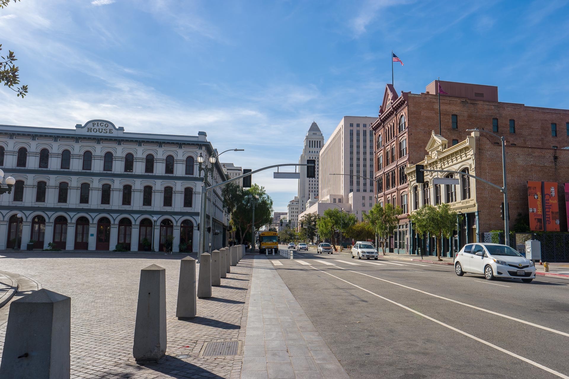
The Plaza
The Plaza was the center of Los Angeles in it’s first 100 years, bounded by Los Angeles Street to the east, Main Street(Calle Principal) to the west with the Pico House and the fire station on the south and Olvera Street(Wine Street) on the north. But this is not the original Plaza, there were at least two previous ones; one closer to the Los Angeles River, and one to the northwest of the current Plaza. Before the Spanish arrived, Los Angeles was a Tongva village known as Yangna that was close to very large sycamore tree. When the Spanish decided to send a settlers from Mission San Gabriel, they located the original plaza by the tree they called el Aliso*. The first Plaza was lost to the LA River flooding, so they moved to higher ground. I’ve not seen anything as to why the Plaza was moved from the second location, slightly southeast to it’s current location. The area east of the Plaza was the original Chinatown and a small alley off Los Angeles Street was known as Calle de los Negros(the American settlers called it something much more distasteful). The construction of Union Station in the mid to late 1930’s displaced Chinatown and it moved north of the Plaza. In the next 20 years due to freeway construction and stupidity(clearing areas for parking lots) many of the older buildings from the mid to late 1800’s were torn down. Los Angeles could have had a nice “Old Town” that would rival other cities, but “hey, we got parking”.
*When the Spanish first arrived in Los Angeles, or Yangna, el Aliso was thought to be about 300 years old. After the Plaza moved to the east, the area around el Aliso first became vineyards and later an industrial area with a brewery located next to the tree. The brewery(folk who lived or visited LA prior to the mid-80’s might remember the “Brew 102” sign over the brewery) was quite successful and continued to expand around the tree(and the tree was trimmed back to accommodate the brewery buildings). The brewery was a partnership of two German immigrants, one loved the tree and the other hated the tree. One day, while the guy who liked the tree was away, a branch fell on one of the beer trucks and the owner that was present ordered el Aliso cut down. When his partner returned, he was so incensed by this that he dissolved the partnership and started his own brewery a mile or so to the east. The location of el Aliso is now marked by a historical marker in the island of a freeway on/off ramp.
Bird’s Eye view of the Plaza.
Taken on 2016-11-28
Los Angeles, California
This is a view to the northeast(remember downtown LA is set out at a 37 degree offset from true north) from LA City Hall. The white building at the center bottom was the US District Court for the Central District of California. Most of the court’s operations have moved to the new federal courthouse next to the LA Times buildings. The Plaza and the historic buildings surrounding it are just to the right of the courthouse.

Pico House and the Brunswick Drug bruilding.
Taken on 2016-11-28
Los Angeles, California
Pico House was built by former governor(under Mexican rule) Pio Pico in 1870 as the finest hotel in Los Angeles. South of the Pico House is the Masonic Lodge(built in 1858) and the Merced Theater(built in the 1880’s). Across Main street is the red brick Brunswick Drug building and a former theater.
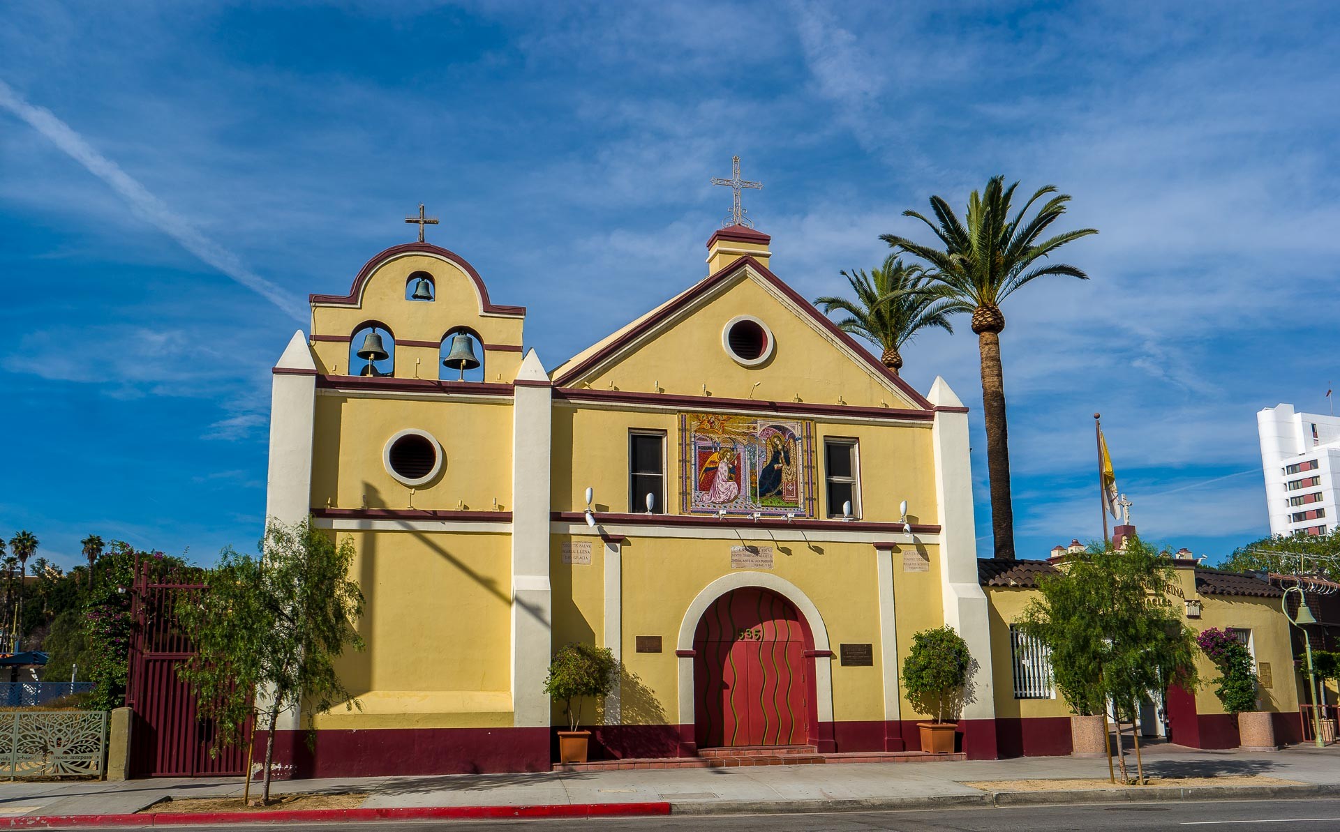
Plaza Church.
Taken on 2016-11-28
Los Angeles, California
The Plaza Church(La Iglesia de Nuestra Señora la Reina de los Ángeles) dates from 1814, though the present structure was completed in 1861(the bell tower was changed in the early 1900’s). The land to the left on the church was the first cemetery in LA.
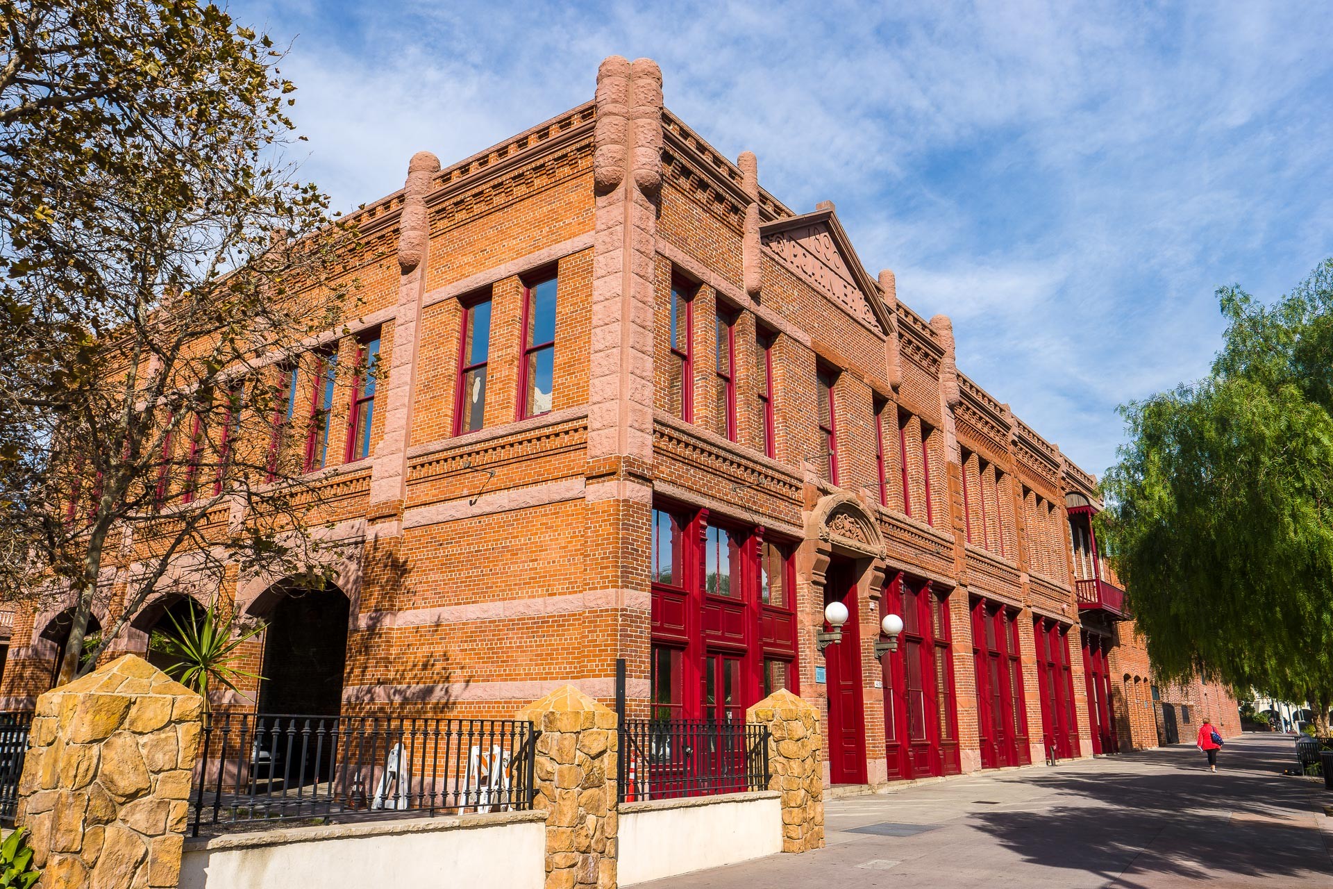
Garnier Block
Taken on 2016-11-28
Los Angeles, California
As I was reading about old Los Angeles history, they keep talking about the Garnier Block or the Baker Block*, or some other Block. It’s quite confusing until you find an old map that has all the “Blocks” labeled, but it’s a really efficient way of identifying buildings once you have a reference. If the building looks a bit unbalanced and the brick on the left looks a bit different; that’s because the southern portion of the building was removed for the construction of the Hollywood Freeway in the early 1950’s.
*The Baker Block was on Main Street where today it crosses the Hollywood Freeway.
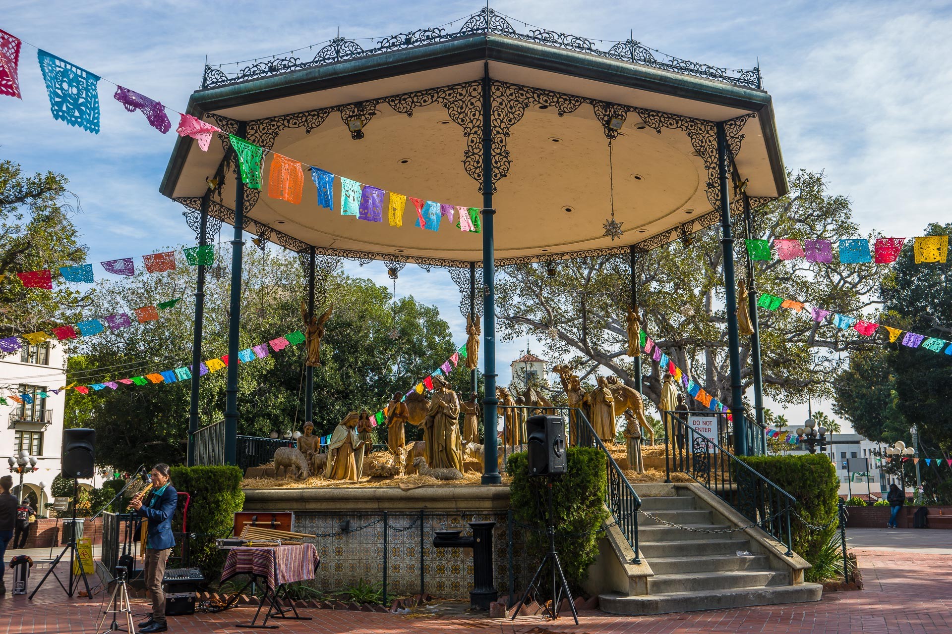
Bandstand in the Plaza
Taken on 2016-11-28
Los Angeles, California
This is the bandstand in the center of the Plaza, being that it was less than a month before Christmas, they had a nativity scene. You can see the tower of Union Station in the background.
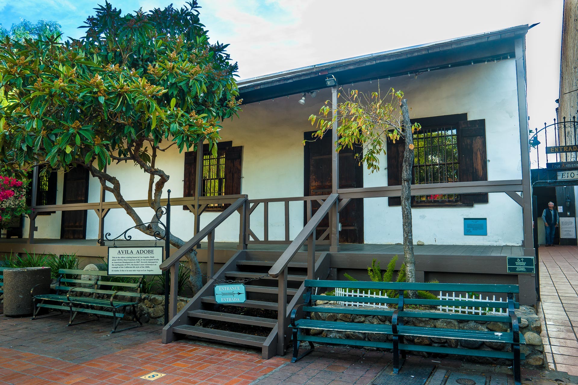
Avila Adobe
Taken on 2016-11-28
Los Angeles, California
This is the oldest building in the Plaza area. The Avila Adobe was built in 1818 and is often(and incorrectly*) called the oldest building in the City of Los Angeles. The adobe is just off the Plaza on Olvera Street. The building whose wall you can see at the right edge of the picture is a former Pacific Electric Railroad power substation. The adobe is open to the public and it’s FREE!
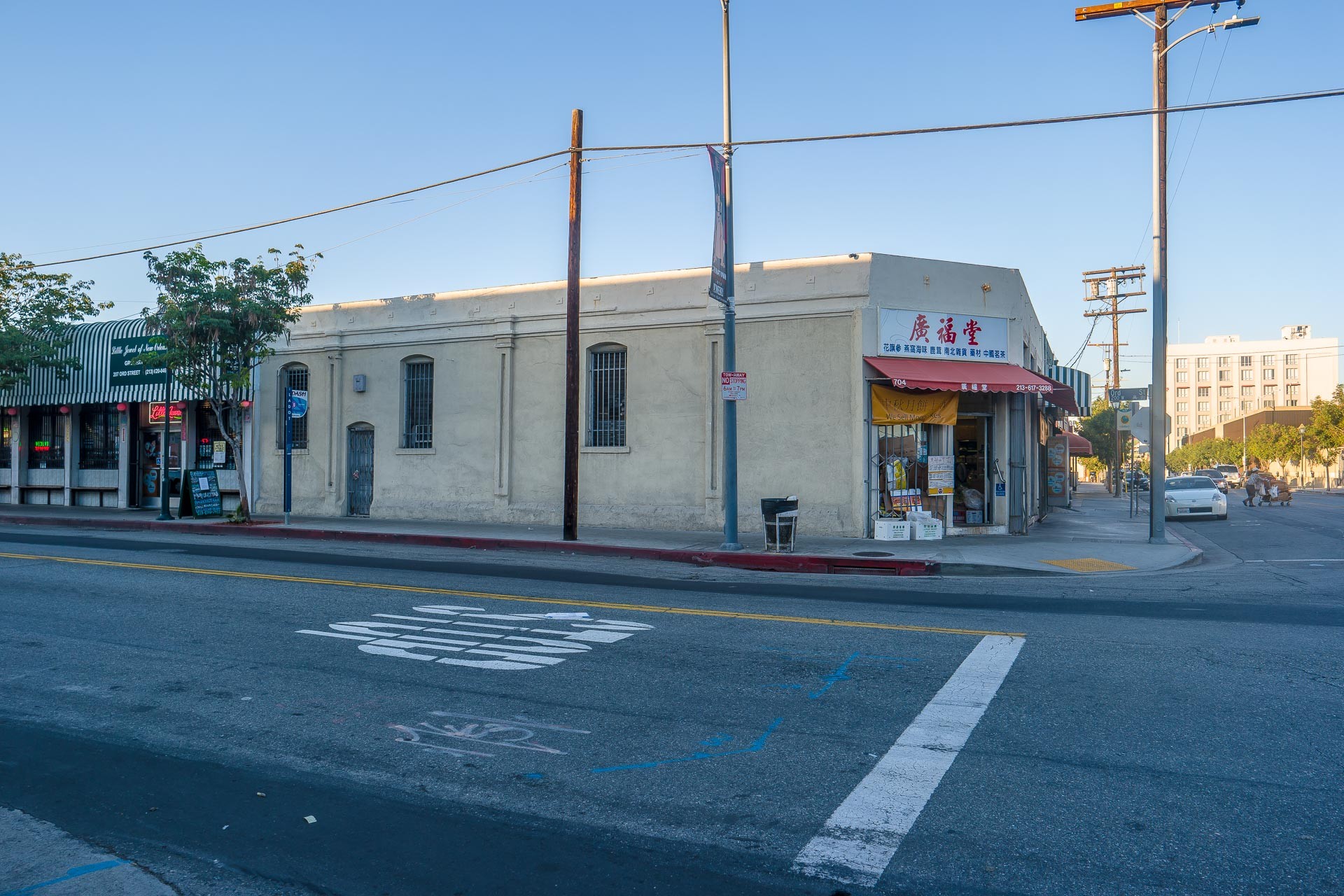
Sunset Hotel.
Taken on 2016-11-30
Los Angeles, California
I’ve added this building to this set, even though it’s not on the Plaza(it’s a few blocks to the north), because it illustrates something about a good number of older buildings in downtown Los Angeles. This building is in Chinatown at the corner of Spring Street and Ord Street. This used to be the Sunset Hotel and was 5 stories high and had turrets. The turrets seem to have disappeared in the early 1930’s, probably due to the Long Beach earthquake of 1933. I’m not sure when the building lost it 4 top floors, but it seems to have occurred in the 1950’s(I did check the building records).
The Sunset Hotel really stood out in old pictures of this area(called Senoratown when it was built in 1887). I had assumed it had been torn down until I found out where it was located. I knew that this was the first floor of the 1887 building due to the arched windows and doors, the detailing, but most of all are the square pieces of metal on the roofline. Those are anchor bolts that were put into masonry buildings after the 1933 earthquake.
Thank you so much ?BillinGlendaleCA, do send us more when you can.
Travel safely everybody, and do share some stories in the comments, even if you’re joining the conversation late. Many folks confide that they go back and read old threads, one reason these are available on the Quick Links menu.
One again, to submit pictures: Use the Form or Send an Email
rikyrah
Beautiful pictures once again, Bill.
Thank you ?
Ruckus
Having owned an unreinforced red brick building similar to this one about a mile or so from here I’d bet that the reinforcement plates and bolts actually come from a later time. I believe a lot of the work started after the 71 San Fernando or as it’s locally known, the Sylmar earthquake. There were laws passed about updating, with time frames that came and went. Not saying it’s impossible but we sold our building in 1989 without having had to do the work. Unreinforced brick buildings were the most common type of building up to about 4 stories tall, around downtown till maybe the late 40s, maybe even later, when a lot of them were no longer useful. But thousands of them remain and have been fixed. I believe public accessed buildings such as stores and restaurants, apartment buildings were fixed first, with industrial buildings among the last.
And yes I have to agree with rikyrah, great pictures.
TenguPhule
Did my pictures make it in or is the new form still bugged?
Schlemazel
Nice pictures & good timing. We were in that exact area yesterday. Started at Angles Flight and the Bradbury building the walked past the iconic City Hall over to the Plaza. They were having a Día de los Muertos celebration so there was a lot to see and do. As tourist we were required to have French Dips sandwiches at Phillipe’s for lunch. The MExican places along Olvera Street were backed up with waits well over an hour just to get in.
?BillinGlendaleCA
@rikyrah:
@Ruckus: Thanks.
Ruckus, it may also depend on where the buildings were. There are buildings that were modified with rods and anchors after the 1933 quake and a number of new laws were passed after that quake. But my point in mentioning the re-enforcement is that it’s a way to tell an older building from newer construction.
?BillinGlendaleCA
@Schlemazel: We locals like the French Dips at Phillipe’s, did you get some mustard to take home with you? Did you go inside the Bradbury? You may see some pics of the Bradbury in the near future.
eclare
Nice pictures and history
?BillinGlendaleCA
@eclare: Thanks, I’ve been hanging around a LA history thread lately.
eclare
@?BillinGlendaleCA: You should give tours out there!
?BillinGlendaleCA
@eclare: I leave that to the professionals, they’re much better than I.
Baud
I really like the blue skies in Bill’s photos. Very inviting. Glad you cleared up that whole smog issue.
?BillinGlendaleCA
@Baud:
Adobe has been very helpful in that task.
Erin in Flagstaff
I’ve been thinking of doing a Los Angeles trip for some time now. I’d originally planned to do the “Hollywood” touristy things, but Bill’s beautiful pictures have me adding a bunch of must-see sites. Thank you!
Schlemazel
@?BillinGlendaleCA:
Sorry I am late getting back to you but it was 2 AM here and I needed sleep.
Yes to all your questions. Philepe’s was one joint that lived up to it’s hype.
?BillinGlendaleCA
@Erin in Flagstaff: “But wait, there More!” You do want to see Hollywood, but that’s like a hour, 2 if you count the subway ride from Downtown. Some of the studio tours such as Warner Bros & Paramount look good(they’re very expensive, so I’ve not been). Just avoid the “tours of the homes of the stars”, since they’re mostly lies anyway.
?BillinGlendaleCA
@Schlemazel: Sounds like you did things right then?.